
The Hidden History Behind Portland's Neighborhoods That Every Buyer Should Know
Portland's current neighborhood map traces directly back to a single afternoon in May 1948, when a flood destroyed Vanport, which at the time was Oregon's second-largest city. The disaster didn't just displace 18,000 people. It triggered decades of housing policy decisions that shaped North and Northeast Portland's demographics and drove displacement patterns that are still visible in today's market.
What was Vanport, and why does it matter now?
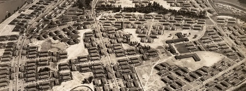
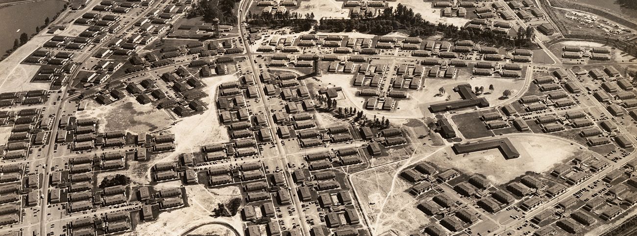
Vanport was a city of over 40,000 people built in 110 days in 1942 on a low-lying floodplain between Portland and Vancouver, Washington. Kaiser Shipyards constructed it to house wartime workers, many of them Black families from the Jim Crow South who had almost no other housing options in a state that had legally excluded Black residents from property ownership since 1844.
I didn't learn this history in any real estate training or licensing course. I learned it by asking questions about why certain Portland neighborhoods developed the way they did, why specific parts of this city were neglected for decades while others accumulated wealth, and why so much of the housing inequality we talk about today has such a specific, traceable origin.
Most people driving through North Portland today have no idea that Delta Park and the Portland International Raceway sit on the land where that city stood. It doesn't look like the site of a disaster. It doesn't look like anything. But what happened there set in motion a chain of housing decisions and policies that directly shaped the Portland you'd be moving into.
Why Black workers had so few housing options in Oregon to begin with
Oregon's exclusion laws weren't incidental history or a regional quirk. Starting in 1844, Oregon passed a series of laws specifically designed to prevent Black people from settling in the territory at all. The state's constitution, adopted in 1857, included an exclusion clause that made Oregon the only free state admitted to the Union with that kind of language written directly into its founding document. Black people were legally prohibited from owning property, making contracts, or using the court system. That clause wasn't formally repealed until 1926.
So when Black workers arrived in Portland for wartime shipyard jobs, they weren't arriving in a neutral place. They were arriving in a state with a documented, intentional history of exclusion, and a city where the Portland Realty Board's own code of ethics explicitly prohibited realtors and banks from selling or lending to Black buyers in white neighborhoods. Redlining wasn't informal or accidental. It was policy.
Vanport wasn't integrated because anyone designed it that way. It was integrated by necessity, because the shipyards desperately needed labor and there was nowhere else for people to go. Even within Vanport, the Housing Authority informally segregated the streets, assigning Black families to specific areas within the development. By 1948, after the war ended and many white workers had moved on, roughly one third of Vanport's remaining 18,500 residents were Black. They stayed not because the housing was good — it wasn't — but because their options outside of it were so limited.
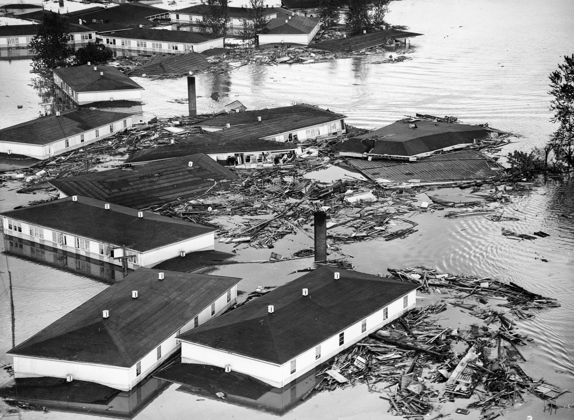
What happened when Vanport flooded
The spring of 1948 brought heavy rain and a faster-than-normal snowpack melt in the mountains. The Columbia River was running dangerously high through May, and residents were nervous. Officials downplayed the risk. On Memorial Day morning, the Housing Authority distributed a notice to residents. It read: "REMEMBER: DIKES ARE SAFE AT PRESENT. YOU WILL BE WARNED IF NECESSARY. YOU WILL HAVE TIME TO LEAVE. DON'T GET EXCITED."
At 4:17 that afternoon, the railroad embankment failed. A ten-foot wall of water rushed in. Within hours, the entire city was gone. The official death toll was 15, though some historians believe the true number was higher and went undercounted. Approximately 18,000 people lost their homes that day.
After the flood, white residents had options. Many had already moved into Portland's broader neighborhoods after the war ended. Those still in Vanport could look for housing across the city. Black residents could not. The same redlining that had confined them to Vanport in the first place was still fully in effect. The only area of Portland where Black families could legally buy or rent was the Albina district in North and Northeast Portland. The problem was that the number of displaced Black residents was roughly equal to Albina's entire existing population. There was nowhere near enough housing to absorb them.
Housing researcher Karen Gibson at Portland State described what followed as the final phase of ghetto-building in the central city. Black families who'd been displaced crowded into Albina, into aging housing stock that white residents were vacating as they moved to the suburbs. By 1960, about 80% of Portland's Black population lived in Albina. The city's schools were, by most measures, as segregated as anything in the Deep South. The pattern of racial transition that would define Portland's geography for the next fifty years was set in motion directly by the aftermath of that flood.
How urban renewal compounded the damage
The displacement didn't stop with the flood. In the 1960s and 70s, urban renewal projects came through Albina and demolished large sections of the neighborhood that had absorbed Vanport's displaced residents. The Memorial Coliseum went in. Interstate 5 cut through. A hospital expansion was planned at a scale that never materialized. Each project required clearing land, and the land that got cleared was the land where Black families had been pushed after they had nowhere else to go.
North and Northeast Portland lost roughly two thirds of its Black residents to the combined effects of urban renewal and, later, gentrification. As Portland became nationally known through the 2000s and 2010s as a desirable, progressive city, property values in those neighborhoods climbed fast, and longtime residents — many of them descendants of people who'd been pushed there after Vanport — were priced out again. The community that had been built there, under difficult circumstances, over decades, was largely dismantled.
What's being done, and what it means for buyers today
The city has made some genuine efforts to address this history. The North and Northeast Preference Policy, established in 2014, gives descendants of households displaced by urban renewal priority access to city-funded affordable housing in those neighborhoods. Albina One, a 94-unit affordable housing development near the Moda Center that opened in 2025, is part of that effort and has brought some families back. These are real programs and they matter. They're also trying to reverse a pattern that took more than 70 years to build.
When I work with buyers in North and Northeast Portland today, I'm working in a neighborhood with that entire history underneath it. The prices you see in Boise-Eliot, Humboldt, or King reflect decades of policy decisions — some deliberate, some neglectful, all of them consequential. Understanding that history doesn't change what you'll pay for a home. But it does give you a fuller picture of the place you'd be moving into, and I think that matters.
Vanport was built on land nobody else wanted because it sat below river level on a floodplain. It was built fast and built cheap, and it was never meant to be permanent. But temporary housing becomes permanent when people have nowhere else to go. The workers who came there — white families from Oklahoma and Arkansas, Black families leaving the Jim Crow South — were all chasing something better. They were told on Memorial Day morning that they were safe. By evening, they had nothing.
What came after shaped this city more than almost any other single event. It determined which neighborhoods grew and which were starved of investment. It determined where wealth was allowed to accumulate and where it wasn't. The effects of those decisions are not theoretical or distant. They show up in the market data I work with every day.
I think understanding this history makes you a more informed person about Portland. If you're seriously researching a move here and want to talk through what neighborhoods look like today — the housing stock, the price ranges, what's changed and what hasn't — I'd be glad to help. Browse my current listings or reach out directly. I'm happy to have that conversation.
Categories
- All Blogs (151)
- Divorce (5)
- Downsizing (6)
- Eco-Friendly Living (4)
- Explore Oregon (38)
- Home Buying (95)
- Home Maintenance (26)
- Home Selling (54)
- Home Styling & Staging (2)
- Join REAL (11)
- LGBTQIA+ (11)
- My Life (4)
- Neighborhoods (21)
- PNW Gardening (8)
- Real Estate History (14)
- Relocation (42)
- Veteran Loans (1)
Recent Posts


LET'S CHAT